Loon Lake – A designated lake of critical status in Washington State.
Loon Lake is located at the top of the divide between the Spokane River and Colville River watersheds. At one time the overflow from Loon Lake actually flowed into Beaver Creek to Dragoon Creek and into the Spokane River. More specifically the lake is located at N latitude 48 degrees 3 minutes W longitude 117 degrees 38 minutes at the headwaters of the Colville River basin.
Altitude: 2,381 feet above sea level
Lake volume: 52,000-acre feet
Mean depth: 46 feet
Maximum depth: 100 feet
Surface area: Approximately 2 square miles (1,100 acres)
Shoreline: Approximately 7.9 miles
Adjudicated Level
In 1950 Stevens County Superior Court established the required maximum lake water level, known as the “adjudicated level,” after a bitter water-level dispute by local citizens. The elevation of 2,381.25 feet above sea level was to be maintained by the Supervisor of Hydraulics of the State of Washington, now known as the Department of Ecology (DOE).
A channel was constructed in the lake’s northwest corner leading toward Sheep Creek, and a control dam with operable gates was built to adjust the lake level. When fully open with the lake at full pool, 20,000 gallons per minute flow from the lake into Sheep Creek. In 24 hours, the water level can be lowered one inch. The dam is still in use today, keeping the lake about 3,500-acre feet smaller at full pool than it would be in its natural state.
Monitoring is now conducted by Loon Lake Sewer District #4 who reports to the DOE. A depth gauge on the control dam was installed and can be read easily from the side of the control channel. Data on water level has been maintained on a regular basis since 1987 by the Loon Lake Sewer District. The district also maintains a U.S. Bureau of Standards Evaporation Pan installed in 2000 that now provides daily evaporation data.
Water Sources
Three sources of water for Loon Lake consists of water that drops onto the lake’s surface, water/snowmelt in the watershed and runs off into the lake, and springs fed by the aquifer.
There are five ways the lake loses water – surface evaporation, outflow through the control gate, seepage to the deep aquifer to the north (Sheep Creek), withdrawal from shallow wells adjacent to the lake, and direct withdrawal from the lake for irrigation.
Essentially the lake is a pothole, totally dependent upon the watershed. The maximum level of the lake, when reachable, is regulated by law at 2,381.25 feet above mean sea level. The minimum level is regulated by Mother Nature. Examination of local weather data indicates that the average net evaporation for Loon Lake from June through September is 31.6 inches. However, lake level records show that average lake level drop for this same period is only 14.2 inches. The additional 17.4 inches of water comes from the watershed aquifer. Modifying the recharge capacity of the watershed through increased residential density is a very risky business in terms of the future of the lake.
Loon Lake is located in a relatively small, closed drainage basin of approximately 14 square miles (7,200 acres) with only intermittent streams that stop flowing in the summer months. The lake has the smallest ratio of watershed to lake surface in the state of Washington, making it very sensitive to changes in its environment. Runoff from the lake and seepage from its deep aquifer form the headwaters of the Colville River. The eastern portion of the watershed is dominated by Loon Lake Mountain (elevation 3,476 feet) to the southeast and Deer Lake Mountain (elevation 3,747 feet) in the northeast. A low ridge at an elevation of about 3,000 feet forms the western and southwestern boundary. The land at the north end of the watershed forms a broad glacial valley which drains northward. Highway 395 roughly bisects the watershed in a north-south direction. The highway and the roadbed of the BNSF railroad roughly parallel the east shore of the lake.
Overview
In the 1930s Loon Lake was nearly surrounded with wetlands, and most of the lake’s east side was wetland. Today, the remaining wetlands make up only about four percent of the original footprint.
The Washington State Wetlands Rating System for Eastern Washington has a four-tier system with Category 1 considered the highest, of vital importance, and Category 4 of least importance.
Loon Lake has five Category 1 wetlands:
- Anderson Meadow
- McVay Meadow
- Pearson Meadow
- Little Loon Lake
- Unnamed wetland, located in Carlson Bay in the northeast corner of the lake
Wetlands help protect public health, safety and welfare by providing
- Flood storage, moderating surface and storm water flows
- Erosion control, reduction of siltation
- Prime habitat for aquatic, terrestrial and avian species
- Passive recreational opportunities
- Protection of water quality, reduction of pollution to ground and surface water
- Water storage
- Areas of recharge and discharge for lakes and groundwater aquifers
- Opportunities for education and scientific research
A buffer is an area that surrounds or is adjacent to a wetland and protects it from adverse impacts. Low impact uses and activities may be permitted within the buffer. Buffers are measured from the delineated boundary of the wetland. The term delineation means the determination of an area’s boundaries in the field according to the application of specific methodology by an agency or qualified professional. In the case of a wetland, the delineation is done in accordance with the Washington State Wetlands Rating System for Eastern Washington.
Is it a Wetland?
In 1991 a group of wetland scientists, planners and regulators came together to develop a wetland rating system that would increase the predictability, certainty and consistency of decision-making related to wetlands. A team of about 35 Technical Reviewers established a draft of a rating system which was sent out to other wetland experts for review and comment. A long list of government agencies was involved – Washington Department of Fish and Wildlife, County Soil Conservation Services, County and City Planning Departments, Washington Department of Natural Resources, departments of several universities, U.S. Forest Service, and the Washington Department of Ecology which initiated the project. Wetland specialists from these agencies developed the Washington State Wetlands Rating System.
The Wetlands Rating Systems Manual is essentially a cookbook on how to evaluate wetlands. It contains 45 pages of forms, criteria, guidance sheets, and how-to materials. It is very thorough on what needs to be done.
How the System Works
The system requires that specific criteria be confirmed on a Wetlands Rating Office Data Form using state agency sources or the application of a field methodology before a particular wetland is assigned a category or rating. The field methodology is strictly prescribed and consists of a Wetlands Rating Field Data Form which provides detailed guidance to the person doing the field work. These two activities make up the database for the evaluation.
The Manual contains a rationale for reasons why some wetlands are more important than others. These are called Wetland Categories 1, 2, 3 and 4.
The Wetlands Rating System is designed to be used by agencies in developing procedures for wetlands protection and for local regulatory programs being developed or revised.
The rating system has specific criteria for determining whether or not wetland classes are present at all, and if wetland classes are present, whether there is enough area of a wetland to score points on the rating scale.
Specific Criteria for Wetland Classes
AQUATIC BED wetland is any area(s) of open water with rooted aquatic plants such as lily pads, pond weed, etc. Aquatic bed vegetation does not always reach the surface and care must be taken to look into the water.
OPEN WATER wetland is any area of standing water present for more than one month at any time of the year without emergent, scrub-shrub or forested vegetation. Open water includes any aquatic beds.
EMERGENT wetland is any area of vegetated wetland where non-woody vegetation such as cattail, grasses, sedges, etc. compose at least 30% of areal cover. The term areal cover means the percent of vegetation covering any area of vegetated wetland. It is used to decide what classes of vegetation are present in the wetland.
SCRUB-SHRUB wetland is any area of vegetated wetland where woody vegetation less than 20 feet tall such as most willow species, hardhack, dogwood, salmonberry etc. comprises at least 30% of the areal cover.
FORESTED wetland is any area of vegetated wetland where woody vegetation over 20 feet tall such as alder, cedar, hemlock, cottonwood, and some willow species, etc. comprises at least 30% of the areal cover.
Delineation
The Manual states… “Before using the Wetland Field Data Form the wetland boundary should be delineated. It is possible to complete the field method with more rudimentary delineation based on inventory maps and aerial photographs. However, it should be recognized that rating based on a less than strict delineation method may result in a different rating than more accurate delineation.”
This is just a very beginning look at the very specific instructions that lead the evaluator through such things as habitat features, plant species, connection to streams, soil type, riparian corridors, etc. The System for wetland evaluation is very detailed and specific. This Manual is based upon years of work by technical experts. The Manual is written by and for the use of individuals with special expertise in the fields of wildlife biology, plant science, soil science, forestry, geography, engineering, hydrology, limnology, land use planning, etc. It is highly unlikely that a layman would have the skills to complete the process of evaluating a possible wetland.
There are a number of sources of information about Loon Lake wetlands. They are shown on the National Inventory of Wetlands Map. The Loon Lake Sub Area Plan, though not enacted by the County, has accurate maps of the lake wetlands. A copy of the Sub Area Plan is available from the Library of the Lakes.
The Control Dam at Loon Lake
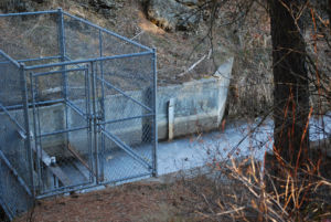
A lake level dispute among Loon Lake citizens in the 1950s could not be resolved and was brought to court. As a result, Stevens County was ordered to construct a control dam and canal leading to Sheep Creek at the north end of the lake in 1951. The cost was apportioned among property owners according to lineal feet of waterfront property owned and assessed by the County Treasurer. Funds were held in a Loon Lake Improvement Fund and disbursed by the County Treasurer.
The dam successfully regulated lake level but did not solve the water level problem completely. The gates were altered to lower the level for various reasons, an action that caused spawning beds for Kokanee to become uncovered. Finally, in 1995, at the request of the Department of Ecology, the Loon Lake Property Owners Association constructed a chain link fence around the control dam to secure it.
Today, Department of Ecology regulates the gate and has the responsibility of control and maintenance of the adjudicated lake level.
Creation of the Loon Lake Sewer District
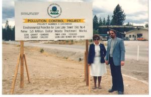
In the late 1970s septic tanks and outhouses were found to be polluting the lake. Something had to be done. The response was the creation of the Loon Lake Property Owners Association, founded in 1979. Its purposes:
- organize property owners within and adjacent to the shores of Loon Lake
- protect the lake from environmental degradation
- provide a forum by which property owners may assist governmental agencies to better plan the use and resources of the Loon Lake area.
One of the first tasks of the organization was a campaign to convince property owners around the lake that a sewer system was the answer to the pollution problem, and by vote of the people, the Loon Lake Sewer District was created in 1980. Funds for building a sewer system came from several sources – Environmental Protection Agency, Department of Ecology, Housing and Urban Development, Loon Lake Sewer District, and Government and Operations Bonds. Construction was completed in 1985 for a total cost of $6.2 million. All property owners within the district boundary were required to connect to the system, except Granite Point Resort which was and is exempt.
Loon Lake Sewer District requires a septic tank on each property, but no drain field. Wastewater is pumped to the sewer line and on to a treatment facility north of the lake. An aerated lagoon is connected to a series of large unaerated detention/polishing lagoons. Effluent is discharged to a spray field that is under cultivation outside of the lake watershed.
The District is managed by three elected Sewer District Commissioners elected for six-year terms.
Creation of the Loon Lake Management District
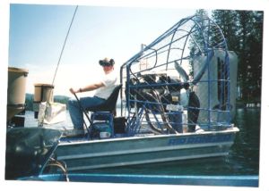
In 1996, while investigating an infestation of purple lustrife in the wetland at the north end of the lake, Jennifer Parsons from the Department of Ecology discovered an infestation of Eurasian Milfoil. Once again, the Loon Lake Property Owners Association (LLPOA) stepped forward to learn about the problem and educate local citizens about how to treat milfoil.
Milfoil in Loon LakeVarious methods of control were attempted – pulling the plants, installing bottom barrier, and, finally, treatment with chemicals. This last method necessitated involvement with Olympia, the DOE and the Army Corps of Engineers to change state law to allow the use of chemicals in the lake.

LLPOA received funds from a DOE Early Infestation Grant to test the use of chemicals on vegetation in the lake. The tests were successful and state rules were changed. Private funds were raised in order to hire a professional corporation to begin the treatments. It became apparent the milfoil battle would be an ongoing annual event. A more reliable funding source would be required. After a very complicated process and very large educational program, the Loon Lake Management District (LLMD) was created in 1999 by vote of property owners. The first authorization was for three years; the next two were for five years. Ongoing support via vote of the property owners has been supported through 2021. Another vote of the property owners will be in mid-2021.
Stevens County Commissioners have the responsibility of appointing a seven-member Lake Management Advisory Committee, the on-site group that directs and makes recommendations regarding treatment. Stevens County Commissioners have the final approval on treatment.
2011 LOON LAKE WATER QUALITY STUDY by Dr. Barry C. Moore, Associate Professor, Washington State University
A summary of the 2011 Loon Lake Water Quality Study was presented June 22, 2012 at the Annual Meeting of the Loon Lake Property Owners Association by Dr. Barry C. Moore, Associate Professor, Washington State University.
Dr. Moore is a limnologist with interests in the movements and effects of pollutants in freshwater ecosystems, particularly on the ecological and management implications of sediment/water interactions. Much of this research has focused on the ecology, analysis, remote sensing, and management of aquatic macrophytes because of their structural and functional roles in eutrophic lake ecosystems. Dr. Moore has directed major restoration studies in Washington lakes and worked with numerous citizen groups on watershed and lake issues, in particular, Newman Lake which is located north of Spokane Washington. His current work includes an evaluation of hypolimnetic oxygenation and aluminum sulfate injection for reducing internal nutrient cycling in eutrophic lakes and investigations of the relationship between sediment heavy metal contamination and morphological deformities in larval chironomids (midges).
A bound copy of the full report of the 2011 Loon Lake Water Quality Study is on file in the History Room of the Old Schoolhouse, Loon Lake, Washington.
View the report (.pdf, 5,479KB)
View appendices, part 1 (.pdf, 9,046KB)
View appendices, part 2 (.pdf, 5,703KB)
Dr. Barry C. Moore presents findings of the 2011 Loon Lake Water Quality Study.
EXECUTIVE SUMMARY
This report describes results for limnological investigations in Loon Lake commissioned by the Washington State Department of Ecology and accomplished in 2011. This study is intended to:
- Characterize current water quality trends;
- Identify potential drivers of water quality; and
- Identify options for potential restoration and long-term management of water quality in Loon Lake.
Over the past decades, noxious algae blooms have negatively impacted water quality in Loon Lake. Primary organisms responsible for noxious blooms are blue-green algae, more properly classified as bacteria (scientific name: Cyanobacteria). Blue greens can accumulate in large concentrations or “blooms” that reduce lake aesthetic qualities. Many blue greens secrete toxins that sicken or kill pets, livestock, and even humans; blooms may necessitate closing lakes for recreation and other uses. Over time, dead blue-green and other algae cells accumulate as lake sediments, where they can cause deep-water oxygen depletion. In short, numerous water quality problems associated with blue greens seriously degrade water for human use and enjoyment and are a major threat to long-term viability of lake resources.
While blooms have not been reported every year in Loon Lake, residents have noted that bloom frequency and severity appear to have been increasing. These concerns were a major driver that led to the present study.
A key aspect of this study was application of new computational methods and technologies that allow for highly accurate determination of whole lake and individual water strata volumes. This information is critical for understanding water quality trajectories in Loon Lake and for formulating potential strategies to manage and protect lake water quality.
CONCLUSIONS
Major findings of this study include:
- Phosphorus is relatively abundant in Loon Lake, so that algae growth is nitrogen-limited.
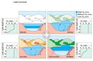 Phosphorus supplies have increased so that nitrogen is currently in shortest supply relative to the needs of algae; that is, algae growth is regulated by nitrogen abundance. In most clean freshwater lakes, phosphorus is the limiting nutrient to algae and plant growth (termed “primary productivity”). Nitrogen limitation is especially conducive to Cyanobacteria growth, as this group has a unique ability to “fix” or utilize dissolved nitrogen gas as a nitrogen source. However, even with nitrogen limitation, phosphorus control is essential to lower overall nutrient availability and to reduce nutrient ratios to more normal that favor desirable algae.
The principal phosphorus source appears to be internal phosphorus loading from sediments resulting from summer oxygen depletion in bottom waters of Loon Lake.
Loon Lake is relatively deep, leading to stable and persistent summer stratification. During summer stratification, the deep waters (termed the hypolimnion) are isolated from the atmosphere. Over many years, organic sediments have accumulated on the lake bottom, where bacterial decomposition of these materials contributes to summer hypolimnetic oxygen depletion or anoxia. Loss of dissolved oxygen (DO) at the sediment water interface (SWI) regulates phosphorus recycling back into the water column. High phosphorus recycling rates occur with anoxic SWI. At Loon Lake, SWI anoxia develops immediately after summer stratification and advances rapidly into the water column. This causes hypolimnion phosphorus to build up throughout the stratification period. At fall turnover, the deep-water phosphorus mixes throughout the lake, and then is available to drive algae growth in the upper water layers (or epilimnion).
Summer anoxia is limiting available cold-water fish habitat by about 84%.
Cold-water fish need low temperature, high DO water which is typically found in the hypolimnion during summer stratification. In Loon Lake, the oxygen loss creates classic temperature/oxygen “squeeze”, where the only suitable fish habitat is along narrow, mid-depth strata at the thermocline. During the summer stratification season, water with adequate DO and acceptable temperature for cold-water fish species is only about 16% of total lake volume. Habitat loss and low DO negatively impact growth, reproduction, and even long-term viability of the cold-water fish community in Loon Lake. Because fish also have less access to their principal prey, zooplankton and benthic invertebrates, indirect water quality impacts cascade through the system.
Loon Lake phosphorus concentrations indicate eutrophic conditions.
Overall, Loon Lake total phosphorus (TP) concentrations measured in 2011 were within ranges found in meso- to eutrophic lakes. Average annual whole lake volume-weighted total phosphorus (VWTP) provides the best indication of lake nutrient status; VWTP in Loon Lake for 2011 averaged 0.028 mg/L.
Loon Lake is in a critical condition relative to water quality. Cyanobacteria blooms will likely become more frequent and more intense in upcoming years.
There will be substantial variation in blooms from year to year, driven by particular climatic and hydrologic conditions for any given growing season. However, basic lake conditions of high overall nutrients and low TN/TP ratios set the stage for substantial algae productivity and favors Cyanobacteria.
MANAGEMENT OPTIONS AND RECOMMENDATIONS
Long-term restoration and management options and a discussion of advantages, disadvantages, and potential costs for each are presented in the final section of this report. Our recommendations involve targeting both external and internal nutrient sources.
External nutrient reduction and controls are essential to long-term protection of Loon Lake water quality.
Because of the diffuse (non-point) nature of watershed sources, external nutrient reductions will largely have to be accomplished on individual properties. To facilitate watershed nutrient reduction, the Loon Lake community is encouraged to form a watershed-planning group to include all potential stakeholders. This group should be tasked with educating and encouraging best management practices on all lands in the Loon Lake watershed. The group can pursue grants to support educational and outreach activities and to support specific management options. Ultimately, the goal is for every user and landowner in the watershed to have knowledge, motivation, and means to reduce nutrient outflows from their property or activities so that there is minimum possible impact on lake water quality.
There are still some homes and units at Loon Lake that are not connected to sewer systems. We suggest that removing all septic wastewaters from the watershed should be a major emphasis for reducing external phosphorus load. Such a task can most economically and effectively be addressed through community action and shared funding opportunities.
Hypolimnetic oxygenation provides the technically- and cost-effective means for internal phosphorus reduction.
Line-diffuser hypolimnetic oxygenation is the most promising option for Loon Lake. This option will not only target sediment phosphorus release but has additional benefits for increasing cold-water fishery habitat. Our recommendation is that a citizens’ organization work to identify and pursue potential funding sources to implement and manage long-term lake management. Long-term management of any internal treatment or watershed nutrient activities will likely require an organizational and funding structure, such as the existing Loon Lake Management District.
The Loon Lake Property Owners Association (LLPOA) serves the Loon Lake community to preserve, protect and promote a healthy and happy quality of life for the lake and the community. Visit the LLPOA website.
